Kensington Gore
|
The world’s largest map fair captures Now in its 38th year, the world’s largest antique map fair runs at the Royal Geographic Society in Kensington Gore on June 17 and 18, with prices from £10 to over £100,000. This event draws dealers and collectors from all over the world, attracted by the classic and the quirky. On the classic front, for instance, this year’s fair offers a copy of the first English County Atlas in London, published in 1579. One of the earliest national surveys of any kind and the first uniformly conceived cartographic survey of England and Wales, Christopher Saxton began designing it in about 1574. It commanded immediate attention and was so treasured that in 1585 it cost £5, ten times the price of the first world atlas, created by Abraham Ortelius in 1570. Surprisingly, although rare, they do appear from time to time, but the example offered by Clive A Burden at the London Map Fair is a one-off: it is the first edition early issue owned by the Earls of Sutherland from 1699, passing to the Dukes of Marlborough and housed at Blenheim Palace until the late 19th century, when it was sold along with the library by the 7thDuke, grandfather to Winston Churchill. The three maps from it illustrated here – Cheshire, Cornwall and Dorset – come in contemporary colour. The price for the atlas is £125,000.
On the quirky front, the London Map Fair boasts a unique pair of caricature maps of Europe. The Comic Map of the Seat of War satirises the relationship between European powers at the onset of the Crimean War in 1854 and is considered extremely rare. The Treaty Map of 1856 satirises these same relationships but at the end of the Crimean War. No other example of this map has been recorded. They were drawn by Thomas Onwhyn – widely accepted as the inventor of this genre – and their publication was hugely influential; it is now considered to be the beginning of a flowering of English satirical cartography continued into the late 19th and early 20th century. The Map House have priced the pair at £25,000.
Also on offer will be a poster map recording the newspaper industry in its glory days of 1926, setting out the titles across the length and breadth of the land owned by Allied Newspapers. Drawn by Leslie MacDonald Gill (1884-1947), the younger brother of the artist and engraver Eric Gill, in graphic design in the Arts and Crafts style, it is priced tag of £7500 with the AlteaGallery Ltd. Gill’s most important commission was from the Imperial War Graves Commission, designing the script used on Commission headstones and war memorials, including the ‘ThiepvalMemorial to the Missing of the Somme’. His ‘Wonderground Map of London’, originally drawn as an advertising poster for London Electric Underground Railway Company in 1914, was such a success it is credited with saving the ‘UndergrounD’ advertising campaign.
17-18 JUNE LONDON MAP FAIR, ROYAL GEOGRAPHICAL SOCIETY, KENSINGTON GORE, LONDON SW7. Prices from £10 to £100,000 among the 40+ exhibitors who come from all over the world. Details: www.londonmapfairs.com
For further details, please contact Lucas Field Media at info@lucasfieldmedia.com or call 07968 952850.
Picture captions
Saxton Map 1, 2 and 3 Three maps from the first English County Atlas in London, published in 1579 by Christopher Saxton. Once the property of the Dukes of Marlborough and in the library at Blenheim Palace, the price tag is £125,000. Maphouse 1 and 2 Two unique pair of caricature maps of Europe from before and after The Crimean War –£25,000 at this year’s London Map Fair on June 17 and 18.
Newspaper map This poster map by Leslie MacDonald Gill records the newspaper industry in its glory days of 1926, setting out the titles across the length and breadth of the land owned by Allied Newspapers – £7500 at the London Map Fair on June 17 and 18.
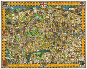
Wonderground map (attached) Leslie MacDonald Gill’s His ‘Wonderground Map of London’, originally drawn as an advertising poster for London Electric Underground Railway Company in 1914 and credited with saving the ‘UndergrounD’ advertising campaign – £3000 at the London Map Fair on June 17 and 18.
Fantasy map A fantasy map of Europe as a Queen from Bunting’s Itinerarium, printed in Magdeburg 1581 – £2850 at the London Map Fair on June 17 and 18. |

|
|